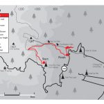

The large green mountain range to the west of the city is, as you all well know, the Doi Suthep-Pui National Park. Here you will find mountains, valleys, villages, roads, viewpoints, waterfalls, tourist attractions, all sorts of critters and fabulous natural wonders one finds in a tropical park as well as an eclectic assortment of offices from a palace to a Royal Thai Navy Seismic Research Station. What is astonishing is that you won’t find many walkers. Chris Ashton, author of Walking on Doi Suthep, has walked each of his 20 day-walks recommended in his book numerous times and says he has bumped into less than a handful of other recreational walkers. His book offers detailed maps, photos and supporting information such as difficulty of walks, what to bring, best time of year to go, and what to see so that you are fully prepared before you embark on your walk, be it an easy two hour amble or a five hour hike. So, if you are up for it, we have highlighted a few of the shorter walks for you to sample:
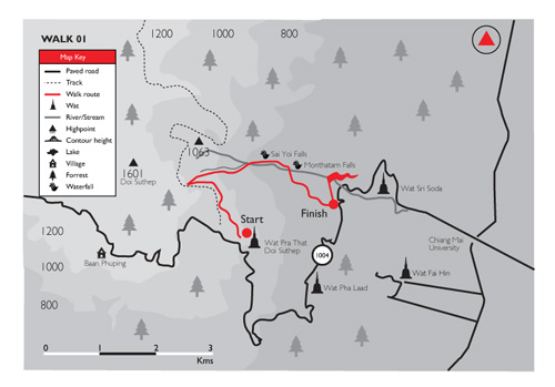
WALK 01
Doi Suthep Temple-Monthatarn Falls (2 hours, 4 kms, 1360 m-500m)
Walk through the lower gateway of Doi Suthep Temple up the first flight of stairs. Do not turn right towards main naga stairway but go straight ahead and find an opening to the left of the stalls facing you. Walk along the downward path and ignore the footpath which goes steeply upwards to your left. The path hugs the contour. This is an easy walk with some of the best scenery on the mountains. You will see signs all along the way and simply follow the ones which say Monthatarn Falls. The path passes small waterfalls and offers sweeping views of the city. Hopefully you can arrange to be picked up at the falls…
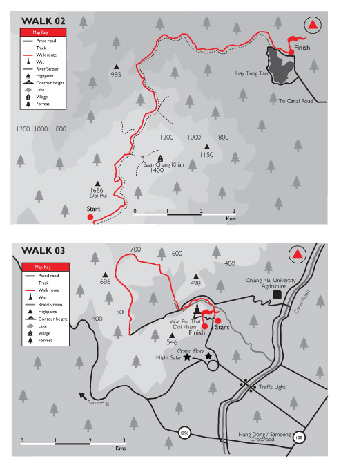
WALK 02
Doi Pui to Huay Tung Tao (3.5 hours, 12 kms, 1540m-360m)
Drive past Doi Suthep car park and Phuping Village to the checkpoint hut at the bottom of the track that leads to the top of Doi Suthep (where the road gives out to clay track). Start waking here…downhill! With the hut to your left follow the track downhill in a NE direction, it will take about an hour to reach the Hmong village of Chang Khian. With the village gate to your right, continue straight. After 15-20 minutes there is a fork, take the right track. Another 10 minutes and take the left fork in the NE direction (small bilingual sign pointing to Huay Tung Tao is nailed to a tree). After nearly two hours you will pass orchards, as you leave the orchards take the right fork downhill. Walk downhill with the stream to your right and continue until you come to a fork where a tree has been struck by lightning, take the left fork. Follow the track which rises through trees, pass a hut on the left and finally you come to a ridge with views to the east and the lake beyond. Food, drinks, transport back and a swim awaits!
WALK 03
Wat Phra Tha Doi Kham (3 hours, 7.5kms, 500m-326m)
Drive to Wat Phra Tha Doi Kham behind the Night Safari. Park at the foot of the hill. Walk along the road north past Doi Kham Resort, cross a small bridge and go up the steep ascent to the t-junction where you turn left. When road forks, take the left fork to cross a small bridge. You are now travelling down a country road with slopes to the right and a small river valley to the left. There are a few houses. You will see a new coffee shop-restaurant to your left. Very soon the road forks, take the left fork over a low bridge. You now continue with rising ground to your left and rice fields spread across flat land to your right, the road is rising ahead to the SW.
After about 10 minutes the road reaches a highpoint and becomes a track. Now look for an old forest path that crosses the track you are now on. The path runs approximately north to SSE, from left to right. Go left to the SSE. Then, after about 10 minutes on this small forest path there is a fork. Take the right fork uphill to the South.
You are now walking though young teak forest. Soon the path levels out and turns towards the east, the left. The path splits two ways at a high point which overlooks the valley below along which the Samoeng Road runs. The Samoeng Road is visible from this point. Take the main path to proceed uphill to the NE.
Follow the path.
After a while you come to a flatish area, there is a small cairn here. You are in the foothills of the Himalayas here – throw a stone on it! Take the path to the right which descends gently to the east.
Soon you come to fenced gardens on either side of the path. The path meets a wide earth track at the back of the Night Safari. Go left. It is now 1.7 kilos to the finishing point.
The track has several turns to the right. Ignore them all and continue straight on heading NE. You pass to your right new buildings which are part of the Chiang Mai University’s Agriculture Department. Continue on past the back of the Royal Flora until you come to the hard topped road that ascends to the Doi Kham temple. Turn right to return to the start.
These are very short and simple directions to three easy walks, for more challenging walks we recommend you get yourselves a copy of Chris Ashton’s Walking on Doi Suthep, lace up a pair of hiking shoes, grab a bottle of water, slap on mossie spray and head out! Happy trails…
www.doisutheptreks.com
www.chiangmaitreks.com